
DOC Maps Notes: A Look at the Department of Conservation's Maps
Previous Entries: July 2017, February 2018May 2018: Lidar is a critical investment for California
Lidar provides critical insight into California's infrastructure, environment, sustainability, safety, and resilience.
This story map has lots of big, beautiful pictures and interactive content, so a fast internet connection is recommended.
Click here to open a full screen view
February 2018: GIS for folks that don't do GIS
If you’ve been listening to ESRI's presentations or reading through their print and online materials, you’ve likely heard of or seen a “Story Map.”
Story Maps are an easy way to build a visually compelling narrative that includes text, graphics, movies, and interactive maps or 3D scenes. The Department of Conservation is starting to get its feet wet with Story Maps. Story Maps prove useful as a way to create interactive stories with, and about our data, but also as a way to make compelling presentations. Recently, I used a Story Map instead of a PowerPoint presentation for a company brownbag talk, called “GIS for people that don’t do GIS.”
The idea behind the talk is that GIS is becoming ubiquitous; even folks that don’t “do” GIS are starting to be able to build GIS applications using data made publicly available as “services.” For example, the DOC publishes a rapidly growing number of map services that anyone can access, build on to answer their own questions or explore geographic information.
Back to the Story Map presentation – my audience was drawn from across the Department, ranging from our most technically savvy to our least. During the presentation, I did a live demo of building a map in ArcGIS Online based on a recent example that came up at the Department. Explore my use of Story Map to explain about GIS here:
Or open the story map full screen in a new browser tab.July 2017: Welcome to DOCMaps
Hi and welcome to DOC Maps.
 Welcome
Thank you for stopping by DOC Maps. We are happy that you’ve come to visit, and hope that you find the data and information useful. Please explore our materials and see what catches your fancy or satisfies your curiosity. Even better, from our perspective, would be that these resources answer the questions you came with and leave you wanting to learn more.
This blog will be a monthly view into what we're working on and why we make some of the decisions that we do about our geographic data. The content may vary from a broad overview of our goals to a niche application of GIS. Regardless, we hope you'll find it interesting and educational. If you would like to make suggestions for the blog, feel free to contact us at gis@conservation.ca.gov.
This inaugural blog entry allows us to say a few words about the Department’s desire to release our geospatial data to the public and introduce the Department's GIS Coordinator.
What about the data?The California Department of Conservation (DOC) has produced a remarkable amount of data throughout its history and continues to generate more on a daily basis. The California Geological Survey (CGS), established in 1860, has more than a century and a half of mapping for the state. Admittedly some of it isn’t in electronic form (yet), but that’s changing. CGS continues to be a prolific producer of scientific data about the state’s geology and associated resources and hazards. Mapping agricultural land change is also within our portfolio, and has been since 1982, with hundreds of detailed county level datasets. The recently renamed Division of Mine Reclamation distributes data about the state’s current and past mining activities, and the Division of Oil, Gas, and Geothermal Resources keeps the state’s oil, gas, and geothermal operations data including amazingly complex spatial representations of subsurface and historical activities.
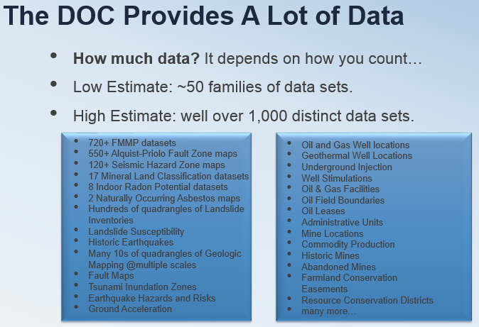
How much data do we have? Like many things, it depends on how you count. The DOC has produced thousands of individual data sets falling into somewhere around fifty "families" of data. Some of these data sets have only a few records, others have hundreds of thousands. Many of these data came from intensive scientific analysis of source data sets with field verification. Others are simpler records of observations that we can then link to other databases.
All of these data and information are inherently spatial. They also span an incredibly wide range of the state’s history, mapping techniques, software packages, versions of software, subject matter, and many require detailed descriptions of what is and is not mapped, and how to draw useful guidance from them.
Making all of this all available to you, the public, while helping the DOC maintain and improve its data, and keeping our technical skills sharp is a fun challenge, and one that will keep us busy for a long time.

Since I’ll be writing many of these posts, we thought it would be a good idea for me to introduce myself as the DOC’s GIS Coordinator. I’m privileged to be the DOC’s inagural GIS Coordinator. Since starting in the position a bit over a year ago, I’ve been working to strengthen the DOC’s practices with GIS (Geographic Information Systems) both internally and externally/publicly. We’ve taken many positive steps forward on both fronts in that time, but still have a long way to go on a path that will always have a "next step."
My experience with GIS reaches back ~20 years and includes degrees in environmental biology (BS) and geography (MA & Ph.D.) from the University of California, Davis, where I also spent 15 years in a career staff position with the Information Center for the Environment. During that time, I worked on a wide variety of projects including the use of GIS for environmental, land use, and transportation modeling. Almost all of these projects included either a requirement or a strong desire to make the data and the results publicly accessible. That theme continues at the DOC. I am an open data advocate and am dedicated to the idea that data should be used to inform decision making processes whether in government or in private practice.
Questions about the DOC's GIS data or suggestions for improvements to this site can be sent to me and the GIS team at gis@conservation.ca.gov.
In future entries:Open Data, Map Services, and Geospatial Scientific and Engineering data in the Department of Conservation.