
Web and GIS Developer Information
The DOC encourages the use of our data in building your own web applications or conducting your own GIS analyses. Please read and understand the disclaimers or limitations on use that are included with each published dataset.
Our data spans a wide range of subjects: geology, agriculture, oil & gas, mining, seismic hazards, and mineral resources. Each dataset developed by one of the DOC's divisions has been assigned to one or more subject areas. These subject areas try to collect data based on common user groups or themes that may reach across the boundaries between programs in the Department of Conservation.
Quick Access
- Service Types: What kind of geospatial data services does the DOC provide?
- Service Endpoints: How can you connect to DOC's geospatial data services?
- Citing Services and Data Sources
- Subject Areas: Curated data collections
- Divisions in the Department of Conservation
- Searchable Service List: Find map, feature, and tile services
Service Types
The Department of Conservation hosts multiple service types for geospatial data. Our in-house GIS is primarily ESRI based and as a result the services are most easily accessible as ESRI's map or feature services.
We offer an increasing number of our services in OGC compliant versions including WMS and WMTS.
ESRI is a commercial GIS software provider for the entire range of use including cloud, on-premisis servers, desktops, and mobile devices.
The Open Geospatial Consortium (OGC) is an industry consortium of over 525 companies, government agencies, and universities participating in a consensus process to develop publicly available interface standards [for GIS data]. --from (OGC)
Map Services
Including: ESRI Map Services, OGC Web Map Service (WMS), OGC Web Map Tile Services (WMTS)
Map services prepare the map content on the server and provide it to the web browser as a series of small images that are placed into a container in the web browser in the appropriate positions. These services can be either drawn (aka rendered) as requests come in (dynamically) or rendered ahead of time with the results stored or cached on disk for faster retrieval and transmission to the client (probably a web browser). In general map services do not support client based analysis such as proximity or suitablity analysis.
Feature Services
Including: ESRI Feature Services, OGC Web Feature Services (WFS)
Feature services provide the GIS data (features) as vector features to the client and rely upon the client to manage the rendering of the data. Users can then perform their own analysis or extract portions of the data for local use.
Tile Services
Primarily hosted through the Department of Conservation's official account on ArcGIS Online, these services provide background image data only.
Service Endpoints
All geospatial services use a service endpoint to access the content. These endpoints are URLs to specific locations on a GIS server. In the case of ArcGIS servers such as the DOC uses, a web browser can be used to view basic information about the services provided. The root for our ArcGIS Server is:
https://gis.conservation.ca.gov/server/rest/services
From that url all services endpoints can be located. Each Division has a folder dedicated to their services. Some web mapping applications produced by the department have folders as well. Within each folder you will find links to the endpoints for each service. The default service endpoint will be an ESRI map or feature service. Services available in an OGC service will have WMS, WMTS, or WFS near the upper left corner of the service's endpoint page.
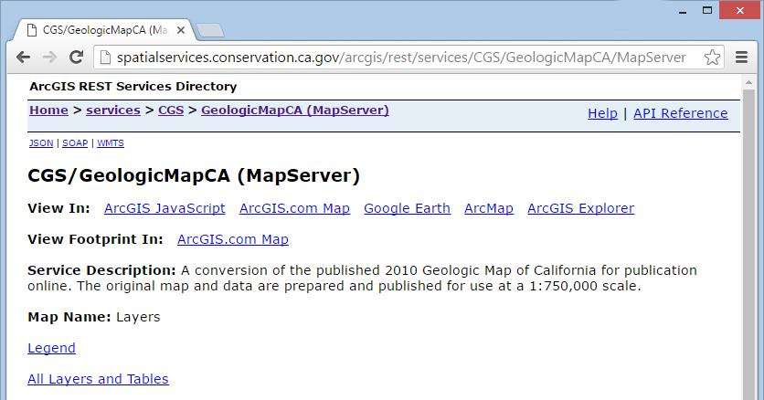
An example endpoint url for the Geologic Map of California map service:
https://gis.conservation.ca.gov/server/rest/services/CGS/Geologic_Map_of_California/MapServer
DOC's services may be hosted through the DOC account on Arcgis.com (ArcGIS Online):
http://tiles.arcgis.com/tiles/zr3KAIbsRSUyARHG/arcgis/rest/services/ms58/MapServer
Citing Web Services
Please cite our web services when used in your application or publications. Citations are used to justify the provision of data and services and to provide clear communication that the data is from an authoritative source.
A suggested citation format:
An example:[author/organizaton], "[Name of Service]", Accessed [Date Accessed], [url]
California Geological Survey, "Geologic Map of California", Accessed February 29, 2020, https://gis.conservation.ca.gov/server/rest/services/CGS/Geologic_Map_of_California/MapServer
Subject Areas
Divisions of the Department of Conservation
California Geological Survey
The California Geological Survey provides scientific products and services about the states's geology, seismology, and mineral resources.Division of Land Resource Protection
The Division of Land Resource Protection works with landowners, local governments, and researchers to conserve the state's farmland and open spaces.Geologic Energy Management Division
The Geologic Energy Management Division, formerly the Division of Oil, Gas, and Geothermal Resources (DOGGR), oversees the drilling, operation, maintenance, and plugging and abandonment of oil, natural gas, and geothermal wells in California.Division of Mine Reclamation
The Division of Mine Reclamation (DMR) provides oversight to lead agencies on a mining operation's reclamation plan and financial assurance. DMR's Abandoned Mine Lands program addresses the state's abandoned legacy mines.Searchable Data List: Services
Notes:- If a service lists [AGOL] then the service is hosted in the Department of Conservation's Organizational account in ArcGIS Online.